Though in many parts of the country summer vacation is just about over, for some, there is still over a month to go. So if you’re a last-minute planner (or you are planning mid-school-year or 2017 trips), here are some places to see in Arizona that are a geologist’s dream.
Something important to know about Arizona is this: The weather varies drastically across the state. From close to sea level all the way up to 12,637 feet (Humphreys Peak near Flagstaff, which, itself, is at about 7000 feet), the state runs the gamut of oppressively hot summers to being snowed in during the winter. So if you fancy a trip in the summer, head to the high country, and if you’re wanting to escape chilly winters, visit the lower areas.
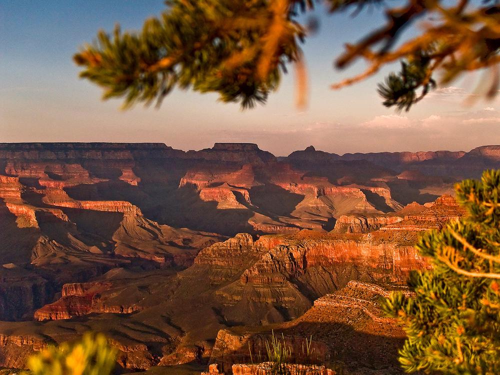
1. Grand Canyon National Park. No list about attractions in Arizona would be complete without one of the biggest canyons in the world. It’s worth a visit, whether you just want to stay in the lodge and walk along the edge, or if you want to hike to the bottom and camp there. (Note: The temperatures are drastically different between the top of the canyon and the bottom. Pack accordingly.) Regardless, the vistas are magnificent, and it’s a prime example of stratified layers of sedimentary deposits. There are plenty of fossils to spot, plus limestone, sandstone, shale, and schist. You’re not likely to ever forget your first time to the Grand Canyon.
(Website, Junior Ranger Program, Guide Books)

2. Antelope Canyon. Among Arizona’s attractions that I have yet to visit, Antelope Canyon is at the top of my list. I imagine carefully frolicking in the nooks and crannies of this rock paradise, alternating taking photos and taking it all in. Located in the Navajo Nation, there are two sections of slot canyons which were formed by the erosion of sandstone, mostly by flash floods, which are common in Arizona. It is extremely popular with photographers, for obvious reasons, but the geology of the area is equally fascinating.
(Guide Books)

3. Meteor Crater. Just off of I-40 lies a giant hole in the ground. But not just any hole in the ground. One that was created about 50,000 years ago by an asteroid traveling 26,000 MPH. Almost a mile across, there is plenty to do there in addition to just looking at it. The site includes plenty of trails, indoor crater viewing (with A/C), an interactive informational center, and a movie about the crater. Guided rim tours are also available.
(Website, Educational Site including Curriculum, Guide Books)
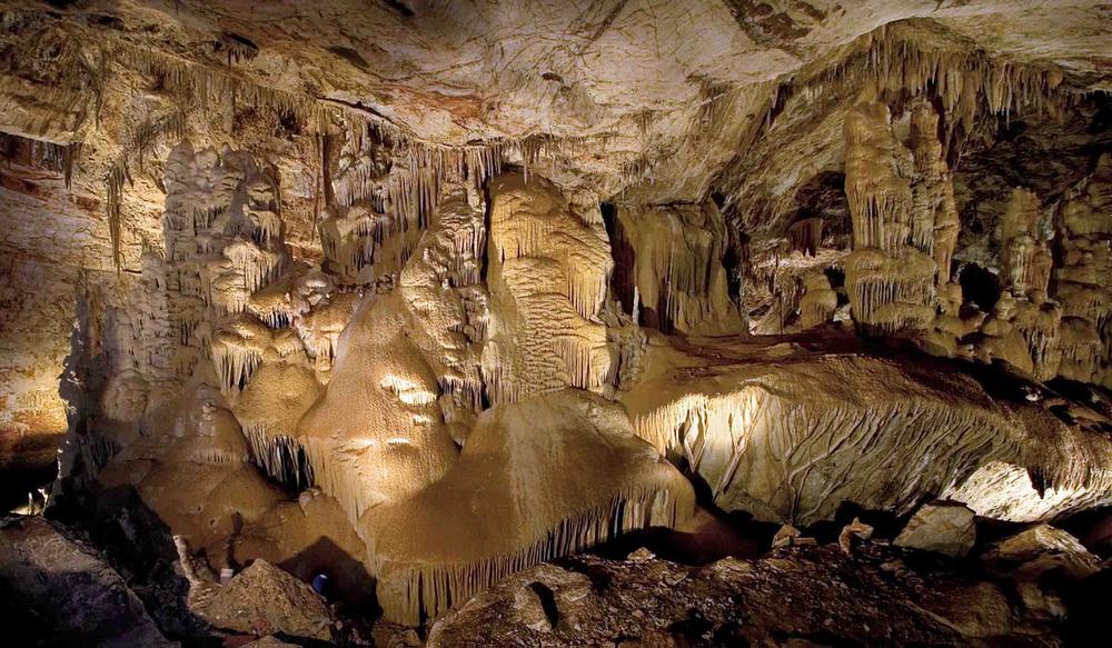
4. Kartchner Caverns State Park. Discovered only in the past 40-odd years, this State Park was set up with a great deal of secrecy, only opening to the public a little over 10 years ago. The history of its discovery is a fascinating read all on its own. Created through the deposit of limestone whose minerals were then dissolved by rainwater, caverns emerged, along with deposited calcite, creating spectacular formations. Kartchner Caverns is a living cave, meaning the formations are still growing and evolving. And, yes, bats do make their home here. The cave is also of interest to mycologists, paleontologists, hydrologists, and bacteriologists.
(Website, Junior Ranger Program and Curriculum, Guide Books)

5. Monument Valley Navajo Tribal Park. Right on the border between Arizona and Utah, this park has everything you remember from the Roadrunner and Coyote cartoons. Created by interesting effects of erosion, the formations of Monument Valley were created by softer rock eroding and leaving the harder rock in place. Filled with mesas, buttes and sparse plant life, it spans over 90,000 acres (also crossing into Utah) and has been shaped by wind and water over the past 50 million years.
(Website, Guide Books)
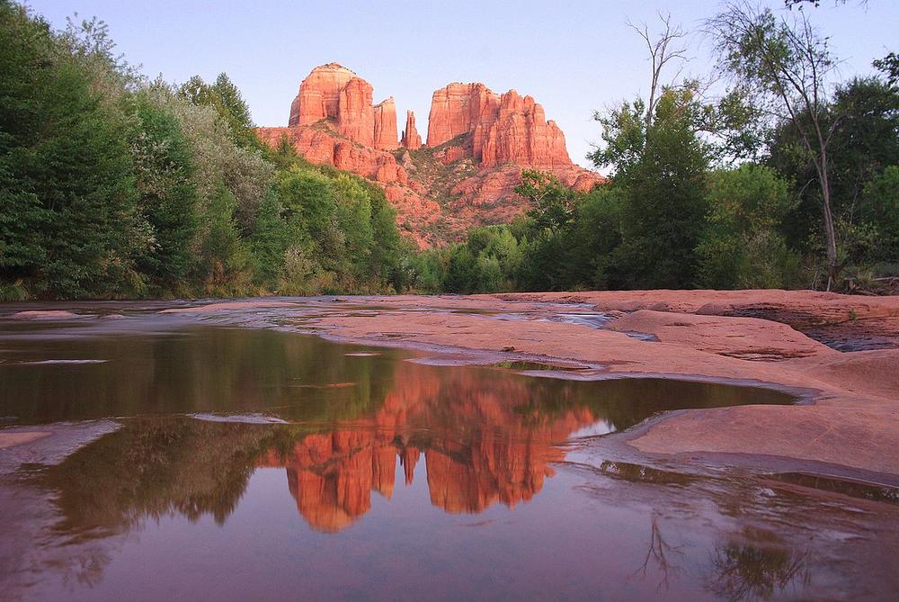
6. Sedona’s Red Rocks and Red Rock State Park. The area surrounding the city of Sedona is filled with gorgeous scenery including red, iron-rich rock formations. It also includes plenty of perennial plants and some rare and unique birds, all winding along Oak Creek.
(Website, Red Rock State Park, Junior Ranger Program, Guide Books)

7. Petrified Forest National Park. If you, like me, thought that the Petrified Forest was just dirt with some petrified tree trunks sitting on the ground, you’ll be surprised to see how much diverse beauty that this National Park holds. In addition to the varied and extensive assortment of petrified wood, the park also has unique southwestern scenery such as interesting erosion patterns and colorful badlands. The northern part of the park also extends into the Painted Desert. The petrified/fossilized wood is from trees from about 225 million years ago, and there are other kinds of fossils from the Late Triassic period as well.
(Website, Guide Books)
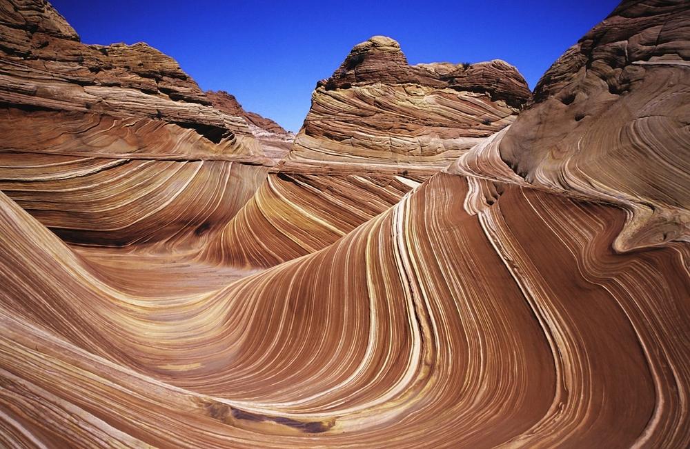
8. The Wave, near Vermillion Cliffs. The picture says it all.
(Website, Guide Books)